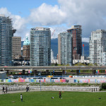
Last week, Vancouver city council voted to remove both the Georgia Street and Dunsmuir Street viaducts just east of the downtown core. Over the past few years, council has crafted an elaborate proposal towards the demolition of the two elevated concrete roadways and their approaches to open up the space for new parkland and housing developments.
Originally part of grandiose scheme to create a massive freeway system into Vancouver’s central business district under the unimaginative label “Project 200“, the Georgia Street and Dunsmuir Street viaducts were the only part of this that were weld into reality (the other is the international-style tower at Granville Square, home to the offices of the Vancouver Sun and Province newspapers). Project 200 would have connected to the Trans-Canada Highway that runs through the city’s eastern border and include a new tunnel under Burrard Inlet to the North Shore while running through Gastown and the waterfront. Nothing more from this project was built.
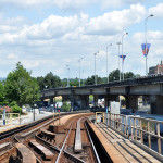
Though these viaducts are not the first as another structure for Georgia Street dated back to 1915 crossed what was then marshy industrial land. Historic communities, including Hogan’s Alley, were destroyed to make way when the new viaducts opened in 1972. The Georgia Street viaduct handles all eastbound traffic while the Dunsmuir Street viaduct handles all westbound traffic.
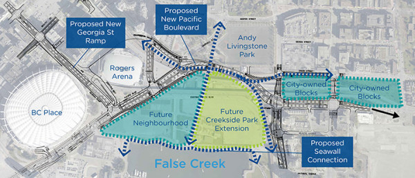
Underneath the viaducts the land has remained relatively barren. A skate park resides beneath Dunsmuir Street at the intersection Union and Quebec Streets, while a parking lot for Rogers Arena lies to the east of the building, surrounded by Pat Quinn Way, Expo Boulevard, Carrall Street and Pacific Boulevard. The afore mentioned Rogers Arena is squeezed between the overpasses and takes advantages of the upper sidewalks to funnel visitors in and out of the stadium. At the eastern ends of the viaducts, on and off-ramps occupy two blocks of city-owned land, which would open up for further development.
Bounded by the SkyTrain tracks and Georgia Street viaduct is Concord Pacific Place, a paved lot that hosts a number of events throughout the year including the giant tents for Cirque du Soleil, staging areas for filming and other community affairs. Part of this spot would become home to an expanded Creekside Park, while the remainder becomes a potential residential zone.
Council has put forth that with the viaducts gone Georgia Street will slope down between BC Place Stadium and Rogers Arena before connecting into re-aligned Pacific Boulevard. Dunsmuir Street will terminate at Beatty Street; traffic will be flow along Pacific Boulevard, up Georgia Street and then onto Beatty Street to reach Dunsmuir Street. Improved connections to Abbott, Carrall, Quebec and Main Streets are being touted as benefits along with seismic stability, beauty and reduced maintenance costs.
In terms of cost, the removal was originally estimated to be $130 million, but recently, that number has spiked to $200 million; a hefty sum for the tear down, road reorientation and development. A Business in Vancouver article mentions that TransLink could be footing at least $10 million as part of its mandate to support the region’s roads and transit infrastructure. In a CTV report, acting city manager Jerry Dobrovolny stated that taxpayers won’t be shouldering the costs and that the money would come from the developers building on newly available land.
Of course, there’s two sides to every argument; an article posted on Van City Buzz expands on the effects of losing the viaducts including the change in traffic flow, concerns over bicycle and pedestrian safety (Dunsmuir Street carries one of the city’s many dedicated bike lanes), and overall costs regarding demolition of the viaducts. The article even provides examples on how the land underneath the existing viaducts could be put to better use, comparing cases from around the world.
While city council may have voted towards removal, the provincial government doesn’t agree with the decision. The CBC reported British Columbia’s Transportation Minister Todd Stone has voiced concerns over plans that impact the movement of commodities and people should be considered at a regional level. Minister Stone added that many users of the viaducts don’t reside within the city of Vancouver, but are average commuters.
However, you have to give some credit to the city for opening up the discussion on the future of the viaducts. On the city’s web site, there are interactive maps with before-and-after images, technical documentation and assessments, and feedback forms for input from citizens. A number of open houses were held to allow citizens to voice their concern and ask questions regarding the plans for the removal of the viaducts and usage of the space.
Even though the fate of the viaducts is sealed, it’s only a matter of time for the road closures to begin as the scaffolding rises to bring down these monolithic transportation arteries.
Did you find a typographical or factual error in this article? Please let us know!